Key Highlights
- Parcel mapping provides a general overview of your property lines for assessment and tax purposes.
- These maps are different from a legal land survey, which offers a high level of accuracy for real estate needs.
- You can access GIS data and parcel maps for free through your local county assessor's office website.
- Understanding parcel numbers and legal descriptions helps you navigate property boundaries and ownership records.
- For construction or disputes, a boundary survey is essential to precisely define your property corners.
Introduction
As a property owner, understanding your land is crucial. Have you ever wondered about the exact location of your property boundaries? Parcel mapping is an excellent tool that can help you visualize your property and its relationship to neighboring parcels. This guide is designed to walk you through the basics of reading a parcel map, explaining what it is, why it matters, and how you can use this valuable resource for land management and research.
What Is Parcel Mapping and Why It Matters for Property Owners in the United States
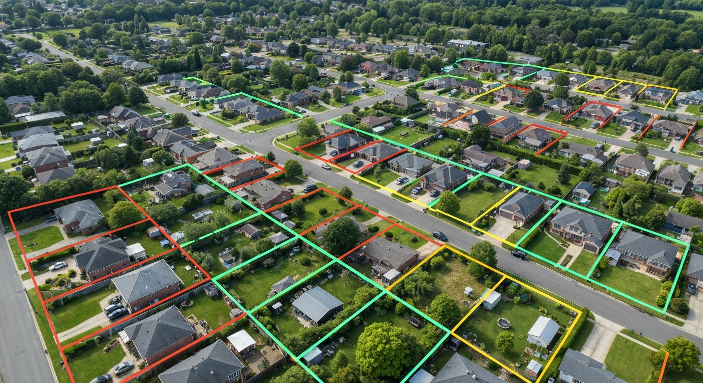
A parcel map is a drawing that displays the layout of properties in a specific area, created by a county assessor for tax and assessment purposes. For any property owner, these maps offer a clear, visual representation of property lines, parcel size, and how your land fits into the larger community. They connect visual data with public records, making complex information more accessible.
While a GIS parcel map provides a fantastic bird's-eye view, it is not a substitute for a legal property survey. Parcel maps are for informational and tax purposes and come with a disclaimer about their accuracy. A legal survey, on the other hand, is a highly accurate measurement conducted by a licensed surveyor and is legally binding for real estate transactions and construction.
Key Purposes of Parcel Maps in Local Property Research
Parcel maps are a valuable resource for anyone conducting property research. They serve several key functions that simplify the process of gathering land information. Whether you're a homeowner or a real estate professional, these maps provide a foundational layer of data for due diligence.
A municipal tax parcel viewer typically contains a wealth of information. You can find details that help you understand a property's context within the local area. The primary purposes of using these maps include:
- Identifying approximate property boundaries and parcel size.
- Tracking property tax and legal updates using unique parcel identification numbers.
- Viewing multiple properties at once to understand neighborhood layouts.
- Supporting land management with references to block and lot numbers.
By accessing these public records, you can get a comprehensive overview before making decisions about a property. They are an essential first step in any property-related inquiry, giving you a snapshot of boundary lines and other critical data.
Who Uses Parcel Maps: Homeowners, County Assessors, and Real Estate Professionals
A wide range of individuals and professionals rely on parcel maps for different reasons. As a property owner, you might use a parcel map to get a general idea of your property's size and shape. It’s a great starting point for understanding what you own without the cost of a full survey.
County assessors are primary users, as they create and maintain these maps for property tax assessment. For them, parcel maps are a critical tool for organizing and managing property data across the entire county. Real estate professionals also use these maps extensively. They help real estate clients visualize a property and its surroundings during the early stages of a transaction.
A title company often references parcel maps as part of its due diligence process when providing title insurance. While they are a helpful resource, the title company will ultimately rely on more accurate survey data and legal descriptions to confirm property rights and ensure a clean transfer of ownership.
Understanding Key Elements Found on a Parcel Map
When you first look at a parcel map, it might seem like a complex web of lines and numbers. However, understanding a few key elements can make the mapping information much clearer. These components work together to provide a detailed picture of land division and ownership.
The most important features include parcel identification numbers, boundary lines, and references to legal descriptions. While these maps are based on survey data, they are primarily graphical representations and not legally definitive documents. Learning to spot these elements will help you navigate the map like a pro.
Parcel Identification Numbers and How They Work
One of the most critical pieces of information on a parcel map is the parcel identification number (PIN), sometimes called an Assessor's Parcel Number (APN). This unique code is assigned to each piece of real property and acts as its official identifier for tax purposes. Think of it as a social security number for your land.
A tax parcel viewer will always display this number prominently. For example, a complete PIN might look something like 123-456-789-000. Each segment of the number corresponds to a specific piece of information, such as the county code, map book, page number, and finally, the individual parcel itself. This system makes it easy for real property tax services to track ownership information and assessments.
Finding your PIN on the map is the first step to accessing a wealth of public records associated with your property. This public service allows you to easily look up your deed, tax history, and other important documents.
Boundaries, Lot Numbers, and Legal Descriptions Explained

On a parcel map, solid lines typically represent the property boundaries. These boundary lines show the approximate limits of your property. You might also see dashed lines, which can indicate features like easements or historical lot lines. While the map gives you a good visual, only a surveyor can physically locate the exact property corners on the ground.
Legal descriptions are not usually written out in full on the map itself, but the map will include lot numbers and block numbers that correspond to the official description in your deed. A parcel map is just one type of property mapping. It’s important to understand how it differs from other documents.
- Map Type: Parcel Map
Creator: County Assessor
Purpose: Created for property tax assessment; provides a general overview. - Map Type: Plat Map
Creator: Licensed Surveyor
Purpose: A legal document showing the division of land into lots; filed with the county. - Map Type: Boundary Survey
Creator: Licensed Surveyor
Purpose: The most accurate depiction of property lines, verified on the ground.
Accessing and Using Online Parcel Mapping Tools in New York
In today's digital age, you no longer have to visit a county office to view property maps. Most counties in New York and across the country offer online GIS (Geographic Information System) portals. As a property owner, this is an incredibly valuable resource for accessing property information from the comfort of your home.
These online mapping tools allow you to search for your property using a parcel address or PIN. Once you locate your parcel, you can view its boundaries, see ownership details from public records, and even use features like data download to save a copy of the map. This makes looking up property information easier than ever before.
Popular GIS Platforms and Municipal Tax Parcel Viewers
The best online tools for viewing parcel data are typically found on your county's official website. Whether you're in Westchester County or another part of New York, a quick search for "[Your County] GIS" or "tax parcel viewer" will usually lead you to the right place. For New York City, the NYCityMap tool is an incredibly powerful resource that combines various data.
These GIS platforms are designed to be user-friendly, often functioning like Google Maps. They allow you to turn different data layers on and off, giving you a customized view. Some common features include:
- Viewing parcel boundaries and aerial imagery.
- Accessing property tax and assessment data.
- Overlaying information like flood zones, zoning districts, and plat maps.
- Measuring distances and areas directly on the map.
This type of interactive mapping is a valuable resource for homeowners, buyers, and developers alike, providing a comprehensive look at any given property and its surrounding context.
Step-by-Step Guide to Finding and Downloading Parcel Data for Your County
Finding and downloading parcel data for your county, whether it's Dutchess County or elsewhere in NYS, is a straightforward process. Most county GIS portals make their public records easily accessible. Follow these simple steps to find the information you need.
Start by visiting the official website for your county's assessor or GIS department. From there, you can typically navigate to an interactive map viewer. The process usually looks like this:
- Go to your county’s GIS or property records website.
- Use the search bar to enter an address or Parcel Identification Number.
- Select your property on the interactive map.
- Explore the available data layers and property details.
- Look for an "export," "print," or "data download" option to save the parcel data or map view.
Many counties allow you to download a complete dataset, which can be useful for more advanced analysis. This access to parcel data empowers you to conduct thorough research on your own.
Conclusion
In summary, understanding parcel mapping is essential for property owners looking to navigate the complexities of land ownership and management. By familiarizing yourself with the key elements of parcel maps—such as identification numbers, boundaries, and legal descriptions—you can make more informed decisions regarding your property. Utilizing online tools and resources can further streamline your research process, making it easier to access vital information about your land. As you continue on your journey of property ownership, remember that effective use of parcel maps can enhance your understanding of your investment and support your future endeavors. If you have any questions or need assistance, feel free to reach out!